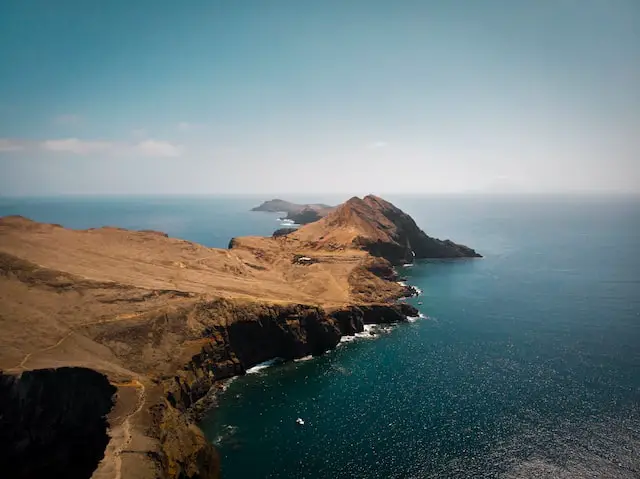

A cape is a piece of land that extends into a body of water, while a peninsula is a piece of land that is surrounded by water on three sides.
Cape
A cape is a geographical feature that refers to a point of land that extends into a body of water, typically the ocean or a large lake. It is a type of coastal landform characterized by its elongated shape and its projection beyond the adjacent coastline. Capes are formed through various geological processes, such as erosion, sediment deposition, or volcanic activity.
Capes can vary in size, shape, and prominence. They can be small and unassuming or large and prominent, often featuring unique geographical formations. Capes may exhibit rocky cliffs, sandy beaches, or a combination of both. They can be found along coastlines all around the world and are often named based on their distinctive features, geographical location, or historical significance.
Capes serve multiple purposes and have played important roles throughout history. They can act as natural landmarks for navigation, guiding ships and sailors. Many capes also serve as scenic viewpoints, attracting tourists and offering breathtaking vistas of the surrounding waters and landscapes. Additionally, capes often experience strong wave action and currents, making them popular spots for water sports and recreational activities.
Famous capes include Cape of Good Hope in South Africa, Cape Horn in Chile, and Cape Cod in the United States. These capes have not only shaped the geography of their respective regions but also hold cultural, historical, and navigational significance.
In summary, a cape is a distinct landform extending into a body of water, showcasing unique features and providing navigational, scenic, and recreational value to coastal areas.
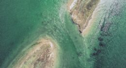
Peninsula
(Photo by Maxim Berg on Unsplash )
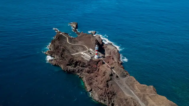
A peninsula is a geographical feature characterized by land that extends out into a body of water, surrounded by water on three sides. It is a narrow strip of land that juts out from a larger landmass, creating a distinct shape resembling an inverted triangle or a finger. Peninsulas can vary in size and can be found along coastlines or within larger bodies of water such as lakes.
Peninsulas often offer a diverse range of landscapes and ecosystems due to their exposure to water on multiple sides. They can feature scenic coastlines, beaches, cliffs, and harbors. Additionally, peninsulas can provide natural protection to the inland areas from the open sea, making them suitable for human settlements and trade routes throughout history.
Examples of well-known peninsulas include the Iberian Peninsula (comprising Spain and Portugal), the Arabian Peninsula, and the Italian Peninsula. Peninsulas play significant roles in geography, tourism, and the economic activities of coastal regions, offering unique habitats, recreational opportunities, and strategic locations for transportation and trade.
Cape vs. Peninsula – Key differences
Cape and peninsula are two distinct geographical features, differing in their formation, shape, and relationship to the surrounding water.
Definition: A cape refers to a pointed landmass that extends into a body of water, such as an ocean or a lake. It is a protrusion of land from the coastline. On the other hand, a peninsula is a landform that is almost entirely surrounded by water but connected to the mainland by a narrow strip of land.
Shape: Capes are characterized by their narrow, elongated shape, often tapering to a point. They can resemble a headland or a promontory. In contrast, peninsulas have a more substantial and expansive land area. They typically have a broader base and can have a variety of shapes, including triangular, finger-like, or irregular.
Surrounding Water: Capes are surrounded by water on three sides, projecting into the open water. They are exposed to the forces of the sea and can experience strong waves and currents. Peninsulas, on the other hand, are mostly surrounded by water but connected to the mainland. They may have a coastline on multiple sides, with calmer waters and potentially more sheltered harbors.
Formation: Capes are often formed through erosion processes, where the sea gradually erodes the coastline, leaving behind a pointed landmass. Peninsulas can have various origins, including tectonic activity, volcanic processes, or deposition of sediment from rivers and currents.
Size: Capes can range in size, from small promontories to larger headlands. Peninsulas are generally larger landforms with more significant land areas. They can be substantial extensions of land into the water.
Significance: Capes often serve as navigational landmarks, helping sailors and ships to identify their location and navigate along coastlines. They can also be scenic viewpoints and tourist attractions. Peninsulas, with their larger land areas, can support diverse ecosystems, human settlements, and economic activities.
Notable examples of capes include Cape Horn, Cape of Good Hope, and Cape Cod. Examples of peninsulas include the Iberian Peninsula, the Malay Peninsula, and the Scandinavian Peninsula.
Capes are pointed landmasses projecting into the water, while peninsulas are larger landforms nearly surrounded by water. Capes are narrower and exposed to the open sea, while peninsulas have a broader land area and are connected to the mainland by a narrow strip of land.
Examples
The Cape of Good Hope in South Africa is a good example of a cape. It protrudes into the Atlantic Ocean at the southern tip of Africa.
The Iberian Peninsula is a good example of a peninsula. It includes the countries of Spain and Portugal and is surrounded by water on three sides.
The Scandinavian Peninsula is another example of a peninsula. It includes the countries of Norway, Sweden, and Finland and is surrounded by water on three sides.
Why is Cape Cod not a peninsula?
Cape Cod is indeed considered a peninsula despite its name, and its classification as a peninsula is supported by its geographical characteristics. A peninsula is defined as a landform that is almost entirely surrounded by water but connected to the mainland by a narrow strip of land. Cape Cod meets this definition as it is a landmass that extends into the Atlantic Ocean and is connected to the mainland of Massachusetts by a narrow isthmus.
The term “Cape” in Cape Cod refers to its shape, resembling a curved hook or a “cape” jutting out into the sea. While the word “cape” is often associated with a narrower land projection, Cape Cod fits the criteria of a peninsula due to its connection to the mainland.
Cape Cod’s land area is extensive, encompassing various towns and natural features, such as the Cape Cod National Seashore. Its unique geography, surrounded by the Atlantic Ocean and Cape Cod Bay, has shaped its distinct ecosystem and coastal environment. The term “cape” in Cape Cod merely refers to its name, while its actual classification as a peninsula is based on its geographic features and connection to the mainland.
What is the biggest peninsula in the world?
The largest peninsula in the world is the Arabian Peninsula. It is situated in Western Asia, bordered by the Red Sea to the west, the Arabian Sea to the south, and the Persian Gulf to the northeast. Covering an area of approximately 3,237,500 square kilometers (1,250,000 square miles), the Arabian Peninsula is home to several countries, including Saudi Arabia, Yemen, Oman, the United Arab Emirates, Qatar, Bahrain, and Kuwait. Its vast expanse and diverse landscapes encompass desert regions, coastal areas, mountains, and fertile plains.
What is the smallest peninsula in the world?
The smallest peninsula in the world is Point Nepean, located in Victoria, Australia. Point Nepean is a narrow strip of land that extends into the Bass Strait, separating the waters of Port Phillip Bay and the open ocean. While its exact size may vary depending on how one defines a peninsula, Point Nepean is considered one of the smallest peninsulas due to its relatively limited land area compared to other peninsulas around the world. Despite its small size, Point Nepean holds historical significance and is now a popular tourist destination with scenic coastal views and heritage sites.
Featured Image By – Tim Roosjen on Unsplash